What are Open Maps?
Open Maps are a tool for digital ‘radical cartography’, challenging Google’s representation of the world; a cheap, portable, pirate WiFi map server developed as part of tech artist Josh Harle’s MuseumsQuartier residency.
What is Radical Cartography?
Radical Cartography is “an alternative to the typical, seemingly neutral vision of geographic space as a static field of mute infrastructure and unquestioned boundaries.” The maps borrow Google’s look and feel – pinch zoom, swipe navigation, dynamically updating map tiles – but present the maker’s own maps: anything from conventional representations to crayon drawn scrawls or biro-annotated sketches.
How does it work?
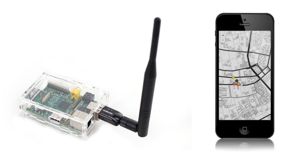
Open Maps are hosted via a Raspberry Pi single-board computer, which can be made weather-proof, and can even be run via battery or solar if mains power is impractical. With an 5dbi antenna/WiFi interface they have a range of about 50 metres, and when installed in an area effectively are ‘visible’ and usable within this range. The cost of each device with enclosure, power adaptor, WiFi, and appropriate weatherproofing is less than €100.
The devices show up as an open WiFi network (many phones/devices will give a notification that it has found an open WiFi network). They could be set up as a number of spatially overlapping Wifi-networks each with a different name corresponding to themes, perspective, or artist. Using HTML5 and javascript and providing multiple formats of media, the devices can host maps, text, video, and audio content. Most of the processing is done on the viewer’s phone or tablet, so it scales well: there isn’t significantly more strain on the Raspberry Pi device as more users connect to it. Users choosing to connect to the open WiFi (no password needed), are automatically forwarded to the WiFi’s landing page.
